ITS for Pedestrian Safety
The U.S. Department of Transportation's (U.S. DOT) 2022-2026 Strategic Plan cites safety as the Department's top priority. A major goal of U.S. DOT is to support livable communities that provide safe and multimodal transportation choices to all citizens, whether by walking, bicycling, transit, or driving.1 As roadway crashes involving pedestrians have been rising in recent years, reducing pedestrian fatalities is a crucial aspect of reaching this goal. Read more and explore the data visualizations below to better understand the issue of pedestrian fatalities and how Intelligent Transportation System (ITS) technologies can be a tool toward reducing them.
Pedestrian Fatality Trends
Pedestrian Fatalities by Year | The National Highway Traffic Safety Administration (NHTSA) Fatality and Injury Reporting System (FARS) provides yearly data on fatalities and injuries suffered in motor vehicle traffic crashes. FARS data show that pedestrian fatalities reached a 10-year high in 2021, with an estimated 7,000+ deaths occurring across the United States. Since 2009, these deaths have increased by more than 75 percent, from 4,109 in 2009 to 7,388 in 2021. The number of pedestrian fatalities varies by time of day. In 2021, nearly 75 percent of pedestrian fatalities occurred at night.2 |
FARS collects more than just raw fatality numbers. It also includes data on the position of the pedestrian on the roadway when the fatal collision occurred. In 2021, almost 75 percent of pedestrian fatalities took place within a travel lane on a roadway. Other prevalent locations of pedestrian fatalities were crosswalks, shoulders, and intersections.
| Pedestrian Fatalities by Pedestrian Position, 2021 |
Pedestrian Fatality Maps
The map below looks at pedestrian fatalities across the United States by county. Each circle represents one county. The size of each circle indicates the total number of pedestrian fatalities recorded in 2021. The color of each circle indicates the rate at which pedestrian fatalities occurred per 100,000 people in 2021.
Pedestrian Fatalities by County, 2021

Tips for Using the Visualization
- Hover over the map to view the control menu in the top left
- Search using the magnifying glass icon
- Zoom in or out of the map using the +/- controls
- Reset your map by using the home icon
- Click on the play icon for more search features
- Hover over data points to learn more information
- Utilize the interactive key at the bottom of the map for more filtering
(Source: NHTSA Fatality Analysis Reporting System (FARS))
The map below also looks at pedestrian fatalities and pedestrian fatality rates per 100,000 people, but by Metropolitan Statistical Areas (MSA). An MSA is an area that includes a major population center as well as its surrounding suburbs and counties that have a high degree of economic and social integration with the core area. Each circle represents one MSA. The size of each circle indicates the total number of pedestrian fatalities recorded in 2021 and the color indicates the rate at which pedestrian fatalities occurred per 100,000 people in 2021.
Pedestrian Fatalities by Metropolitan Statistical Area (MSA), 2021

Tips for Using the Visualization
- Hover over the map to view the control menu in the top left
- Search using the magnifying glass icon
- Zoom in or out of the map using the +/- controls
- Reset your map by using the home icon
- Click on the play icon for more search features
- Hover over data points to learn more information
- Utilize the interactive key at the bottom of the map for more filtering
- Please note that the legend differs from the previous map visualization
(Source: NHTSA Fatality Analysis Reporting System (FARS))
Agency Adoption of Pedestrian Safety ITS
ITS technologies have been proven to help address pedestrian safety problems. Given the rise in pedestrian fatalities nationally, agencies have been adopting ITS to better protect pedestrians. ITS can improve pedestrian safety by actively detecting them in the environment or by enabling them to make themselves known through methods like pressing a button. That information can then be relayed to other road users, providing greater awareness and preventing fatalities.
Arterial Agency ITS Safety Technology Adoption (Source: ITS Deployment Tracking Survey) | The ITS Deployment Tracking Surveys, conducted approximately every three years, measure the deployment of ITS among freeway, arterial, and transit agencies. The 2020 ITS Deployment Tracking Survey for Arterial Agencies found that nearly 50 percent of surveyed arterial agencies in large- and medium-sized metropolitan areas have adopted pedestrian warning systems, a statistically significant increase from 2016. A significantly larger number of arterial agencies have adopted Pedestrian Warning Systems compared to other ITS safety systems. |
State and local agencies around the country have found success implementing pedestrian safety technologies. Below are three examples of agencies that have successfully adopted pedestrian safety ITS systems and the resulting benefits.
ADOT Pedestrian Hybrid Beacon Effectiveness: The Arizona DOT found that after the implementation of 52 Pedestrian Hybrid Beacons (PHB) at certain road intersections, the annual adjusted pedestrian-related crash rates at these intersections fell from 0.18 to 0.09 crashes. | Pedestrian-related Crashes Before and After PHB Installation (Source: Arizona Department of Transportation/Texas Transportation Institute (TTI)) |
Miami-Dade Pedestrian Collision Warning (PCW) and Pedestrian Safety: The Miami-Dade County Transportation Authority found a significant improvement in bus drivers yielding to pedestrians when PCW was activated (88 percent) compared to when it was not activated (58 percent). | Percent of Drivers Yielding to Pedestrians With and Without PCW Systems (Source: Florida Department of Transportation (FDOT)/Florida International University (FIU)) |
NYCDOT Thermal Camera Pedestrian Detection Rates in High-Traffic Corridors: In a connected vehicles (CV) study, the New York City Department of Transportation (NYCDOT) found that in high-traffic corridors, thermal cameras exhibited over 80 percent accuracy in detecting pedestrians in three of the four time periods measured. These thermal cameras exhibited nearly 90 percent accuracy at detecting pedestrians at night. | Thermal Detection Accuracy of Pedestrians by Time of Day (Source: C2Smart/U.S. DOT ITS JPO) |


ITS Benefits - Pedestrian Safety
ITS Benefits measure the effects of ITS on transportation operations according to the six goals identified by the U.S. Department of Transportation: safety, mobility, efficiency, productivity, energy and environmental impacts, and customer satisfaction.
A few examples of the benefits of pedestrian safety systems are highlighted below:
ITS Costs - Flashing Beacons for Pedestrians
There are a broad range of ITS technologies and applications that can protect vulnerable road users. Flashing beacons for pedestrian detection are an example of an ITS safety solution that can be effective from both a safety and cost standpoint. See the box-and-whisker plot below to explore how the unit costs of pedestrian beacons vary.
Pedestrian Beacon Unit Cost Data by State DOT (Sources: Colorado DOT, Michigan DOT, Virginia DOT) | This plot compares cost data for pedestrian flashing beacon assemblies across 3 State DOTs: Colorado, Michigan, and Virginia. Data are sourced from several years but adjusted to the same dollar-year (2022). The plot shows that although the variance of pedestrian beacon unit costs differs across states, the median cost is similar across all three. This median hovers between $5,000 and $7,000. Virginia shows the most variance in cost while Michigan shows the least. For more information on box-and-whisker plots, click here. |
ITS Lessons Learned - Pedestrian Safety
ITS Lessons Learned capture the real-life experience of practitioners in their planning, deployment, operation, maintenance, and evaluation of ITS projects. They are a reflection on what was done right, what one would do differently, and how a project could be more effective in the future.
A few examples of ITS Lessons Learned related to pedestrian safety are highlighted below:
U.S. DOT Safety Initiatives
With safety as its top priority, U.S. DOT has undertaken a number of efforts to address pedestrian safety. These include the National Roadway Safety Strategy (NRSS) and Every Day Counts (EDC) programs highlighted below.
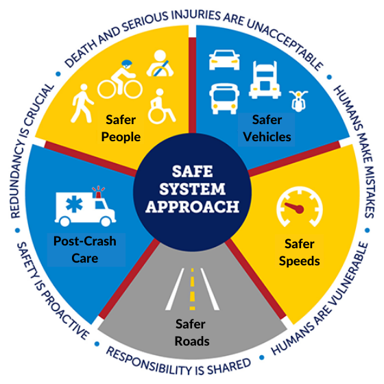
Safe System Approach U.S. DOT's National Roadway Safety Strategy and the Department’s ongoing safety programs are working toward a future with zero roadway fatalities and serious injuries. In support of this approach, safety programs are focused on infrastructure, human behavior, responsible oversight of the vehicle and transportation industry, and emergency response.3 |
Every Day Counts 
Every Day Counts (EDC) is a State-based model run by the Federal Highway Administration (FHWA) that identifies and rapidly deploys proven, yet underutilized innovations that make our transportation system adaptable, sustainable, equitable and safer for all.4 Every two years, FHWA works with State transportation departments, local governments, tribes, private industry and other stakeholders to identify a new collection of innovations to champion. Round 7 of the EDC Initiative: This year, there are several categories that align with pedestrian safety, including Nighttime Visibility for Safety and Next-Generation Traffic Incident Management (TIM). |
References
U.S. DOT FHWA, “Pedestrian and Bicycle Safety”. Last modified June 2023. https://highways.dot.gov/safety/pedestrian-bicyclist
U.S. DOT NHTSA, Fatality Analysis Reporting System (FARS). 2021. https://www.nhtsa.gov/crash-data-systems/fatality-analysis-reporting-system
U.S. DOT, "What is a Safe System Approach". Last modified October 2022. https://www.transportation.gov/NRSS/SafeSystem
U.S. DOT FHWA, "About Every Day Counts (EDC)". Last modified June 2023. https://www.fhwa.dot.gov/innovation/everydaycounts/about-edc.cfm